Unique, Unusual, and Downright Strange Places in Washington County
By Jeff Thoreson

Josh Goldman has stuff. Lots of stuff. Lots and lots of old stuff. He loves stuff.
He keeps it all in his 20,000-square-foot shop he calls Junkworks, an American Pickers type of place brimming with tens of thousands of items that an untrained eye might classify as junk. Like you would see on the History Channel show, Goldman has signs, old gas pumps, furniture, knick-knacks, and stuff so quizzical that you have to ask what it is and what it was ever used for.
“I just always liked old stuff,” Goldman says. “My mom used to drag me around antique hunting, probably not knowing it would one day lead to this. I developed my love of old stuff from that.”
His stuff comes from all over the place—yard sales, private estates, farms, old barns, attics, garages. “Sometimes I door-knock and find things that haven’t been touched for a long time,” he says.
Asked what kind of budget he operates with, his father, Mark, chimes in: “If we got money in the bank, we buy.”
Goldman says he’s loved antiques and things since 2003, but opened Junkworks in Charles Town, W.Va., in 2014. They moved the shop to East Baltimore Street in Hagerstown in 2017. Goldman does all the buying, but selling is a family effort, including Mark, his brother and partner Dan, and his mother Lynne Erting, who was an original partner and came up with the catchy name.
“We specialize in good, old stuff,” says Josh. “I used to focus mainly on automotive collectibles, but now it’s a little bit of anything that is old. Rule 1 is it has to be good. Rule 2 it has to be old.”

Goldman initially thought he would be an automobile restorer, and even sought out McPherson College in Kansas, the only place where one can pursue a career in restoring cars. He earned a bachelor’s degree in automotive restoration, but his drive changed one day, and he told his dad he really liked the idea of collecting antiques.
Like American Pickers stars Jersey Jon and Robbie Wolf, who visited Junkworks in 2022, Goldman is “100 picker.”
“Judging the value of something is very subjective,” he says. “If it’s a mass-produced item you can just look up comps online. If it’s a one-of-a-kind item, I just use my gut and my years of experience buying and selling unique items.”
Customers come from all over. Travelers along Interstate 81 pull off to browse, and locals come back often to see what’s new in Goldman’s old junk. Instagram is a big sales tool.
“I’d like to think Junkworks has a reputation as a destination because of the wide variety of items we sell,” Goldman says.
If you’re looking for the Walmart of stuff—old stuff—Junkworks is probably your place.
On a Wing and a Prayer
Rich Hiegels once soared off High Rock Overlook at the top of Mount Quirauk in Smithburg’s Pen Mar Park and climbed to 12,000 feet on a hang glider. Another time he launched from High Rock and flew to Baltimore. For decades High Rock attracted experienced hang-gliding pilots from throughout the Middle Atlantic and beyond.

“High Rock was right up there with the top three or four spots for hang gliding on the East Coast,” says Hiegels, who started gliding there in the late 1970s as equipment became safe and affordable. At 1,800 feet above sea level and more than 1,000 feet above the usual landing site, the sheer drop-off allowed gliders to soar over the scenic Hagerstown or Middletown valleys and float safely back to Earth.
“On a good day back then you couldn’t even have your car up there because every inch of that area would be filled with 50, 60, 70 gliders preparing for launch and sometimes even the access road would be full of gliders,” Hiegels says.
Gliding began at High Rock in 1975. At first, gliders ran off a rudimentary launch pad of planks attached to pillars. But because they were essentially launching off a cliff, a platform was installed. Then a lower platform was built where other pilots would help the launching pilot control the nose of the glider in the strong winds, updrafts, and thermals that made High Rock such a desirable (and difficult) launching site.
These days, launches have dwindled to just a handful a year, and though some say hang gliding has been outlawed from High Rock, there doesn’t appear to have ever been an official decree forbidding it.
Instead, a number of variables factor into the decline of High Rock gliding. There is less interest in hang gliding as paragliding has grown in popularity. Because launching from High Rock was difficult, it took a small group of pilots to help the launching pilot. Without being able to count on that aid, High Rock fell off the radar of pilots. Airspace is more restricted. If a glider wants to do a long flight from High Rock, the pilot has to first fly north to navigate around the restricted airspace of Camp David. Flying “cross country” to Baltimore or Washington, D.C., is also limited now because of restricted airspace. And the landing field changed ownership. The previous owner was more welcoming to landing pilots.

Without regular activity at High Rock, it became a space for kids to hang out and party. Now the launching area is covered in graffiti—not urban art type of graffiti but just reckless paint that makes the rock more slippery and even more dangerous for gliders.
Hiegels, 66, says he went to High Rock with a few other pilots last year to try to get one more flight in before he quit gliding, but the conditions weren’t right, so he didn’t launch, although others did.
In 2025 it will be 50 years since gliding began at High Rock. There’s talk of a re-gathering of pilots to celebrate, but whether there will be enough interest is a big question.
Magically' Saving the Link Between East and West
In the early days of the 19th century, travel to the settlements cropping up in Western Maryland was anything but easy, with mountain passes to negotiate, creeks and rivers to ford, and danger from wildlife and uneasy indigenous people to avoid.
Commerce moving from Baltimore and Washington crossed South Mountain and descended into the peaceful and easily negotiated Hagerstown Valley until seven miles west of Hagerstown wagon trains encountered Conococheague Creek. A shallow-but-wide section of the creek just south of where the Hagerstown Speedway now stands could be forded.
As commerce grew, it became clear a bridge was needed, and in 1819, the county commissioners budgeted $12,000 for the project. Local mason Silas Harry built the bridge with limestone quarried locally. When it opened it was celebrated as a major milestone in Maryland commerce, a link between the east and west. As a marker at the bridge now commemorates, “It was a major improvement to the road system between Baltimore and Cumberland, providing a continuous smooth surface from the eastern seaboard to the western wilderness.”
The five-arch bridge continued to serve the ever-changing flow of commerce for more than 150 years, accommodating everything from horses in the early days to 18-wheelers much later. In 1972, Hurricane Agnes ripped through Maryland, turning the Conococheague into raging flood water that seriously damaged the Wilson Bridge. When the water receded, structural engineers determined it needed to be permanently closed to traffic.

A new bridge was built less than 200 feet downstream, and now the National Pike (U.S. 40) veers slightly left creating a “Y” with Wilson Bridge Park Lane to flow traffic across the “new” bridge, now half a century old.
With no regular maintenance to Wilson’s Bridge, stones began falling from the 210-foot span and eventually an entire section collapsed, forcing a decision to be made on the future of the now-historic five-arch bridge, the longest stone bridge in Washington County.
The Washington County commissioners had public safety issues and budgetary constraints to consider as the volume of the discourse on what to do with the historic structure turned louder. The Washington County committee of the Maryland Historical Trust fought to save the bridge, but the commissioners, facing a $600,000 estimate to rebuild it, were set to vote to tear it down.
Then, almost magically, a local mason named LeRoy Myers, stepped up and said he would rebuild the bridge for $100,000. The commissioners were on the verge of voting to spend $30,000 to raze the bridge, but when they discovered Myers was serious, voted to spend the $30,000 on Myers’ renovation. State and federal funds, as well as private donations, made up the other $70,000, and now the rebuilt structure, standing in full view of traffic passing on its replacement, is on the National Register of Historic Places. If bridges can have fairytale endings, Wilson’s Bridge certainly does.
The Bast of Boonsboro (Boonsborough?)
When Doug Bast was 9 years old, one of his mates brought an old bottle to school. Fascinated by it, Bast bought it for $1.
“I brought it home and my father said, ‘You paid a dollar for that thing?’ I said, “Yeah, look at it. Look at the color. I really got excited over it,” Bast said in an interview before he died in 2021.
Another story Bast often told was about a trip with his mother to the Smithsonian Institute. On the way home the young Bast proclaimed that, one day, he wanted a museum just like that one.
Those events turned into a lifelong obsession with collecting historic artifacts and documents, the result of which is the tens of thousands of items now in the Boonsborough Museum of History. Bast opened the museum in 1975 and continued to collect for the rest of his life.
“Doug never had a TV,” says museum board of directors president Charles Schwalbe. “He lived in a small apartment above the museum and spent all his time studying, researching, writing, and consulting with people. It was the entire focus of his life.”
Consequently, Bast’s museum isn’t a dinky, small-town stop to look at a few interesting artifacts. It is an enormous treasure trove of historic significance. Bast had collected many thousands of documents, many of which he hadn’t gotten to read thoroughly before his death. Now the board of directors, with the help of a consultant, is going through everything piece-by-piece to classify everything.
“Until two-and-a-half years ago when Doug passed away, this was a private collection,” Schwalbe says. “After his death, it became the stewardship of Doug’s non-profit organization. At that point, we started studying the collection and going through it with a very, very fine-tooth comb, and we discovered things that were heretofore unknown to anyone. As these documents become accessible to the public, they will add to the narrative of what we know worldwide.”
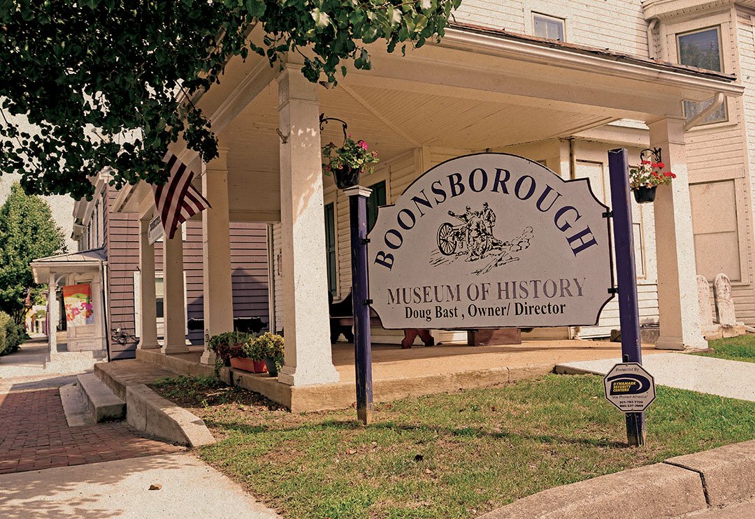
The museum is only open Sundays from 1 p.m. to 4 p.m. because that was the only time Bast had to offer tours. He managed the family furniture store next door called Bast of Boonsboro, which closed in 2011 after 175 years. At the time, it was the longest operating furniture store in the state.
Now the board has plans to turn that building into a museum annex, not only to house more of Bast’s artifacts and documents but to provide meeting and community space. “We want to leave the original museum the way Doug left it and renovate the building next door to expand on his vision for the benefit of the community,” says James Rogers, who sits on board of directors. “We don’t want to change this because this is the way the founder developed it. Everything in here he placed by hand.”
Schwalbe says Bast’s collection includes “boxes and boxes and boxes” of documents that Bast may have perused but never talked about. As the inventory progresses, the board is uncovering interesting documents like maps of proposed routes for the National Pike and documents reflecting the very early history of Washington County, many of which have been unseen for decades.
“A museum is where you go to look at things behind glass,” says Schwalbe. “But what we have are thousands and thousands of documents that came out of people’s attics and various other places. Doug was an avid collector of paper material, books, records, ledgers, and such, and when you start studying these things carefully, you get some fine-grain detail on what came before us. These are important insights into our past. We really want to make a contribution to a more scholarly inquiry into Washington County’s past.”
But why is the name of the museum spelled differently than the town? The town was incorporated as Boonsborough in 1831, but local newspapers and villagers preferred the name Boonsboro. The former name was used on some documents as late as 1903.
A Cave of Civil War Desperation
An illustration that appeared in the Oct. 25, 1862, issue of Frank Leslie’s Illustrated Newspaper, a noted weekly periodical of the time, shows a crowd of people huddled in a cave opening near the Potomac River and more headed to the cave on horseback. News didn’t travel quite as fast in those days. The genesis of the illustration occurred a few weeks earlier on Sept. 17, when the Battle of Antietam was unfolding near Sharpsburg.
As the battle raged near Sharpsburg, area residents grew concerned and sought safety. Many gathered at the Killiansburg Cave near the Potomac River, which faced away from the battle, protecting citizens. Still, it had to be a hollow feeling to listen to the sounds of not-so-distant war while having no idea what might be happening to their homes, farms, and crops.
Killiansburg Cave is rather small, actually not much more than an overhang, and certainly would not have been hospitable for any length of time for such a large group. The battle lasted only one day, though it was the bloodiest single-day battle of the war.
The cave is near milepost 75.7 on the C&O Canal and sits about 25 feet above the Potomac.
Defending WaCo through Four Wars
The 18th century genius of the star-fort design developed by French military engineer Sébastien de Vauban played a significant role in Maryland’s military history as his design standards were deployed in the construction of Fort McHenry in 1798. But as famous as McHenry is, that wasn’t the first star-shaped fort built in Maryland. Fort Frederick, begun at the outset of the French and Indian War in 1756 near Big Pool, uses the star design of Vauban, then considered the father of modern fortification.
Alarmed by reports of bloody insurrections on the colony’s western front, Gov. Horatio Sharpe urged the general assembly to fund the fort, one of the largest fortifications built by English colonists in North America, and then oversaw much of the construction himself. The fort’s exterior walls are 355 feet from bastion point to bastion point and the stone wall is about 18 feet high. When it was complete in 1758 at least three major buildings stood within its walls. Two years later, concerned by cost overruns, the assembly cut off funding, though it is believed the fort was largely completed by that point.
Oddly, though in service for four wars, the fort was never directly attacked. After the French and Indian War, Sharpe reactivated the fort in 1763 when Ottawa chief Pontiac led a rebellion against the English. Sharpe armed the fort with weapons and militia but the only action it saw was settlers flocking inside for protection when turmoil seemed apparent.
Reactivated again for the Revolutionary War, Fort Frederick ended up housing as many as 1,000 British prisoners following the battles of Saratoga and Yorktown. The structure lay abandoned again until the Civil War when it was rearmed to protect the C&O Canal and the B&O Railroad.

There was a minor skirmish in the area between Maryland’s 1st Infantry and Confederate raiders on Christmas Day 1861, but the military usefulness of the fort had all but vanished by 1862 and the fort was again abandoned.
In 1922, the fort, now somewhat deteriorated, and the surrounding area was acquired by the state and put into service as Maryland’s first state park. Thanks to archaeological investigations and the discovery of the original plans, the fort was restored to its 1758 condition in the 1930s by the Civilian Conservation Corp. Now more than 260 years old, Fort Frederick is one of the longest-standing structures in Washington County.
Scribes and War
Ever wonder where the name Gathland State Park came from? The park straddles the Washington-Frederick County line along the top of South Mountain, but unlike many of Maryland’s parks it is not named for a geographic feature.

Gath was a pen named used by George Alfred Townsend, who added an H to his initials because of the Biblical passage Samuel 1:20: “Tell it not in Gath, publish it not in the streets of Askalon.” Born in 1841, Townsend wrote for the Philadelphia Inquirer and later the New York World and was believed to be the youngest war correspondent during the Civil War. He was the World’s Washington correspondent in 1865 and his dispatches in the month following the assassination of Abraham Lincoln were eventually complied into the book The Life, Crime, and Capture of John Wilkes Booth.
Townsend became one of the most respected journalists in the nation, later writing for the Chicago Tribune, the New York Evening Graphic, and becoming the founding editor of The Capital in Washington, D.C., with Ohio journalist and politician Donn Piatt.
In 1884, Townsend began building a compound of buildings on South Mountain. The estate, which he called Gapland, eventually included several buildings, including Gapland Hall, Gapland Lodge, the Den and Library Building, and a mausoleum, which would forever go unused, but still stands with the inscription “Good Night Gath.”
In 1896, Townsend added to his estate the War Correspondents’ Memorial Arch, a tribute to war journalists. Displayed on the monument is a statue of the Greek god Hermes (Roman god Mercury), the messenger of the gods and the gold vane of a pen bending a sword. Quotations appropriate to the art of war correspondence are inscribed on the monument, as are the names of 157 correspondents and war artists. Although in the late 1990s, local historian Timothy J. Reese analyzed the list and asserted that only 135 served as war correspondents or artists.
Townsend’s wife, Elizabeth Evans Rhodes, died in 1903 and in 1911 Townsend left Gapland for New York City, where he died three years later. He is buried in Laurel Hill Cemetery in his native Philadelphia, thus his mausoleum remains empty.
Coffee, War, and a Future President
When the Confederate states seceded from the Union and the Civil War began in 1861, thousands of Ohio men rushed to enlist. Among them is a 19-year-old schoolteacher named William McKinley.
He ended up in the 23rd Ohio Infantry, which famously ended up near Sharpsburg on Sept. 17, 1862. As the bloodiest single-day battle of the war raged, young McKinley, the commissary sergeant in charge of feeding the soldiers, was safe at the rear, two miles behind the fighting.
As he listened to the sounds of battle, he saw soldiers, scared and confused, coming back seeking a respite. McKinley had the idea of bringing food to the soldiers and started brewing coffee and putting food on two wagons, rounded up a couple of old mules, and headed by himself toward the battle.

Gen. J.L. Botsford of the 23rd Ohio Regiment would later write: “When you consider the fact of leaving his post of security, driving right into the middle of a bloody battle with a team of mules, it needs no words of mine to show the character and determination of McKinley, a boy at this time about 20 years of age.”
When McKinley entered politics, the tales of his bravery became a political asset, the story told and retold on the stump, including the campaign for the presidency.
A 33-foot-high monument commemorating McKinley’s act, erected just south of what is now the Burnside Bridge parking area, was dedicated by Ohio veteran’s organizations in the Antietam Battlefield on Oct. 13, 1903, two years after McKinley was assassinated in Buffalo, New York. The inscription on the monument says McKinley “personally and without orders served hot coffee and warm food to every man in the Regiment, on this spot and in doing so had to pass under fire.”
Steamboat Credit Where Credit is Due
If American engineer Robert Fulton is credited with inventing the steamboat, why is there a 75-foot-tall monument to a guy named James Rumsey overlooking the Potomac River in Shepherdstown, West Virginia, claiming he invented a steam engine capable of propelling a boat with hydraulic jet propulsion? And why should we in Washington County, Maryland, care?

Rumsey, born in Cecil County, Maryland, was a bit of a jack-of-all-trades. He was a successful miller, mill mechanic, mill designer, canal builder, blacksmith, and a capable architect. He moved to Berkeley Springs, West Virginia, where he met and designed a house for George Washington, who was surveying the town. The two remained acquaintances although Washington probably wasn’t interested in Rumsey’s milling or blacksmithing. Eventually, Rumsey began work on an engine he claimed would propel a boat without wind power. Others called him “crazy Rumsey” but apparently Washington took note, writing in his diary on September 6, 1784, that Rumsey’s model and “its operation upon the water…not only convinced me of what I before thought…quite impractical, but that it might be turned into the greatest possible utility in inland navigation.”
A few years later, “crazy Rumsey” turned out to be quite sane, demonstrating on Dec. 3, 1787, a scale version of what would become the steamboat. Washington urged Rumsey to seek financial support for his invention, and Rumsey was able to enlist Benjamin Franklin and others, who created the Rumseian Society to help fund the invention.
Needing a patent but no U.S. Patent Office yet (that wouldn’t come along until 1836), Rumsey headed for England. On Dec. 20, 1792, the night before he was to demonstrate his invention, he was suddenly stricken by severe head pain. He died the next morning with doctors attributing his death, according to the Smithsonian American Art Museum, “overstraining his brain.” He was buried at St. Margaret’s Church on the grounds of Westminster Abbey.
A sad loss, but Shepherdstown’s gain. In addition to the monument, the bridge leading into Shepherdstown over the Potomac from Washington County is named in Rumsey’s honor, and at the Rumsey Steamboat Museum, opened in 1988, visitors can see a working replica of his model steamboat, which was built by the Rumseian Society to celebrate the bicentennial of his demonstration on the Potomac.
That’s all well and good for Shepherdstown, but the little-known fact of this matter is that the Potomac River is owned almost entirely by Maryland. Therefore, Rumsey’s little demonstration officially took place in Washington County.
A Cavern that’s Crystal Clear
When Crystal Grottoes Cavern was discovered and turned into a tourist attraction, owner Ralph Downs said the cavern was so spectacular it would make money for 100 years. He was wrong. It’s now been 101 years that the cavern just southwest of Boonsboro has been making money, and there are many more to come.
There are, perhaps, thousands of cave systems in Maryland—and who knows what’s out there that hasn’t been discovered—but the only cave open to the public for tours is Crystal Grottoes.

It was quite by accident that the cave was discovered. During a quarrying operation to mine gravel to build Md. 34 southwest of Boonsboro, a crew drilling holes to place explosives on land leased from a local farmer went a little too deep and their bit fell through a hole and disappeared. Air poured out of the hole. A blast opened up an entrance to a cave.
The farmer, who history records know only by his last name of Hurtzell, asked the state to find another place to search for gravel. Unfortunately, Hurtzell died with no heirs and in his will gave the land to his closest friend, Downs. He worked on the cave for two years, running electrical lines and building a log cabin around the entrance. In 1922 he opened Crystal Grottoes to tours for 7-cents a person.
The original wooden structure burned in 1938 and was rebuilt, only to burn again in 2008. It has been replaced by a stone building—the stones quarried from the cavern—that now serves as the entrance way. Little has changed inside the cavern, other than the development of a walking path that connects several rooms full or geological formations perhaps millions of years old.
Visitors get a tour of about 30 minutes and a question-and-answer session follows. Guides discuss geological facts and point out formations that resemble people, animals, and inanimate objects. Stalactites that hang from the ceiling and flowstones—sheetlike deposits of calcite or other carbonate minerals that have built up where water flows down on walls are prominent and impressive features.
Crystal Grottoes is now on the fourth-generation of ownership in the Downs family. Ralph passed it to his son, Gerald, who passed it to Gerald Jr., and now Cassie Downs runs the business on the threshold of its second century.